Rivers, bridges, sweeping roads and scenery to die for
It all started thirty years ago when some very good friends from New Zealand, who had been living in UK for a long time (as New Zealanders seem to do), asked me to be godfather to their youngest daughter.
Skip forward to very recently and Beth, my goddaughter, was now all grown up and getting married. Would we come to the wedding?
Well… Here was the perfect excuse to visit New Zealand and do that motorcycle trip we had so often dreamed of on the South Island. Maybe visit Hobbiton on the North Island as well. My wife and I are both fans of the Lord of the Rings. So Yes! Of course we were coming.
After a long flight with a jet-lag busting stop-over in Singapore we arrived in Christchurch and met up with Paul and Liz, our good biking friends from Austria, who had decided to join us for this part of the trip.
The next morning we picked up our 3 bikes (two Yahaha MT-09s and one Honda NC750x) from the very friendly Kiwi Motorcycle Rentals just outside the city and soon found ourselves heading out of quake ravaged Christchurch into new territory.
 Ready for the off – Kiwi Motorcycle rentals Christchurch

After a lot of very long, very straight roads through flat agricultural land we were slowly getting closer to the mountains. Arthurs Pass – the highest in New Zealand and our route across the island to the west coast – would be our real introduction to the bikes, the roads, the single track bridges and some of the weather we might expect on the rest of the trip. Rain and high winds were forecast for later in the day so we didn’t want to make too many stops before we were over the pass. Bad weather up there would be no fun at all! We cracked on and the weather got progressively duller as the ride got progressively more interesting. These roads feature wonderful long sweeping bends and straights that encourage a brisk pace tempered by strong gusty side winds encouraging the opposite.

‘Memories of North Wales’
The road up to and over Arthur’s Pass was reminiscent to me of all those times I drove from the Midlands to North Wales through the Snowdonia National Park back when I was at University in Bangor. The climb is gradual with sweeping bends, no hairpins here, through wide valleys with gently rising mountains reaching up towards the darkening clouds above. Perhaps it was this threatening weather that also added to my memories of North Wales.
 Castle Hill on Arthurs Pass Road
The super wide glacially formed valley floors are traversed by single track bridges with directional right of way. Some of the longer ones have white wooden side fences stretching away across a desert of grey gravel to a centre point of turquoise blue water. They resemble wooden piers jutting out from a pebble beach towards a distant ocean. They almost look like they have been built as temporary structures in expectation of being repeatedly swept away by frequent flooding rain storms.
 Single lane bridge over Waimakariri river
 The gang at Waimakariri River
We entered the town of Arthurs pass over yet another single track bridge and could have missed it altogether with a blink. To call it even a village would be an exaggeration. A few well spaced single story wood construction buildings, including the General Store, Cafe, Motel and a few bars, are scattered along the sides of the road which runs parallel to the train line on the right. And then you are through.
We were soon descending from the hight point of the pass towards the famously wet west coast and the wind was getting stronger as the sky ahead got blacker.
 Arthurs pass – Starting the descent
I knew there was a point up ahead where you could branch off to the right and climb up to get a spectacular view of the 440m long Otira Viaduct. This elegant construction was completed in 1999 and spans what used to be a very dangerous, avalanche prone section of our route. As the weather was getting worse I had already decided to give the viewpoint a miss. As we passed the turn off and approached the viaduct itself there were rows of orange cones down the road and a stopping point with a temporary traffic light that had just been set-up. It was red. The two very friendly highway employees who had set it up explained that we would probably have to wait around 20 minutes before we would see it go green. Then they left us to it.
 You’ll have to wait here until you get a green light
After what seemed like an eternity of inactivity, during which time the wind had increased to dodgy levels, and a few trucks and cars had come past in the opposite direction, we were finally off. Rolling carefully across the exposed bridge whilst being buffeted by strong side gusts I was pleased that no-one could come the other way. A row of cones soon forced us over to the right to avoid spoiling the fresh new tarmac that was drying on the left.
 Crossing the Otira Viaduct
The remainder of the day was a race against the worsening weather through increasingly lush surroundings to emerge relatively dry and victorious in glorious sunshine on the west coast. A very pleasant ride up the coastal road past farmsteads with white picket fences and fields full of sheep found us at our overnight stop in Greymouth on the West Coast.
Day two: ‘Forest – River – Bridge – repeat’
After a great breakfast at the Seven Penny Cafe in Greymouth the next morning we headed off down the coastal highway 6 towards Fox Glacier. After a lovely sunrise the day turned dull and overcast and the long straight road was relatively uninteresting.

 Leaving the Beachview Motel in Greymouth
That was about to change.
After some 60 km following the coast the road turned inland and entered the Waitaha Scenic reserve across the Waitaha bridge. The flat open land on the coast was suddenly transformed into dense temperate rainforest crowding the road on both sides. A wonderful snaking corridor through towering trees emerging from an impenetrable undergrowth of lush ferns, epiphytes, mosses, liverworts, orchids and lichens. Just fantastic.
 Crossing Waitaha Bridge
 Riding through Waitaha Scenic reserve
The word tropical kept coming to my mind as I had only ever seen anything like this in places like Malaysia and Papua New Guinea – but this is a temperate rainforest with broad leaved trees and a climate to match. Luckily for us, even though this region is normally wet and rainy (‘It always rains on the West Coast’ is the common mantra) – for us it was dry and even had occasional shafts of sunlight piercing the cloud cover and illuminating to road ahead.
After a dreamy traffic free ride through this Disney like vegetation tunnel we passed Lake Lanthe, occasionally visible through breaks in the vegetation on our right, just before emerging from the forest to run along the side of the vast flat Wanganui River basin. A few impossibly long single lane bridges traversing glacier blue rivers running down from the snow capped mountains visible to our left, brought us across the basin to the village of Hari Hari and a delightful lunch stop at the Pukeko Store and Cafe. New Zealand seems to be a paradise for those suffering from gluten allergy. Even out here in the tiniest cafes in the smallest villages there is always a good range of gluten free options.
 Parked up for lunch at the Pukeko Store & Cafe
Whilst eating our homemade goodies (not gluten free in my case) on the tables outside we noticed with amusement that many of the locals wore welly boots (I guess it’s normally wet and muddy out here) which they respectfully took off and left in a neat line outside the door of the cafe before entering.
Back on the road we soon re-entered the rainforest and experienced one of the most enjoyable stretches of road for the day. Equally as lush as what went before but bending and twisting, rising and falling like a fantasy rollercoaster. The road condition in this part of the South Island is generally good but the surface is very coarse and sometimes it was difficult to be sure if the approaching corner was covered in loose gravel or fixed tar seal.
 Whataroa Bridge
 Geoff and the two Lizzes on Whataroa Bridge
After several cycles of ‘rainforest – river bed – single lane river crossing‘ and repeat – we found ourselves riding a series of climbing hairpins that would have been a lot more fun in different weather. The sky was darkening and it had started to drizzle. We made it to the end of our days ride and checked into Lake Matheson Motel in the town of Fox Glacier just before the real rain came.
It would rain all that night and most of the next day but that evening at least we had a blast. A great meal in the super hospitable and great fun ‘Cook Saddle Saloon’ on the main drag. Our umbrellas waited for us at the door.
Day three: ‘So this is why they call it rainforest’
 Temperate Rainforest near Thunder Creek Falls
For breakfast we walked around the corner to the Fox Glacier Guiding Cafe. Apart from coffee, this place usually organizes tours and helicopter trips to the glacier (shrouded in cloud that day) and has a ticket counter where the customer stands on a weighing plate as part of the booking process. I’ve always thought that would be a good idea when purchasing regular air tickets. It seems somehow wrong when I’m paying excess baggage fees and the next guy to check in weighs more than me and my luggage together and he pays nothing.
This was our weather day. We started under dark skies and drizzle too gentle for wet weather gear. The ride itself was great but with the weather so overcast and dull it was a challenge to fully appreciate the wonderful rainforest lushness we were passing through. At Haast we stopped for lunch and donned our wet weather gear as it was properly raining now.
 Knights Point lookout – West Coast
The next long section of riding was an affirmation of why this is called a rainforest. A moodily beautiful ride snaking through the dark emerald forest on wet tarmac with a backdrop of mountains shrouded in multiple layers of clinging mist often descending to and enveloping the road as well.
 Rainforest Riding
 Rainforest Riding
After tracking along the Haast river for some 30km we made a brief stop at the Thunder Creek Falls and walked down through the dripping forest to the viewpoint. We felt a bit like Alien invaders in our full wet weather gear, but it was worth it.
 Aliens in the rainforest
 Thunder Creek Falls
Skip to 35km further along the road and we had stopped for a break at the Wonderland Makarora Lodge where we met some local bikers. The weather was improving when we left, so we removed our wet weather gear again and continued on towards Lake Wanaka with out new found friends in tow. On drying roads and under rapidly clearing skies we blasted around the eastern edge of this turquoise lake on what is a really great motorcycling road. It was the first chance I’d had to put my MT09 through its paces along some decent twisties and I could definitely feel the extra ‘umph’ it has over my Tiger 800. I liked it!


We stopped at Lake Wanaka lookout to take in the view and let our friends go by. Even though we live in the Lake district of the Austrian Alps and are used to aquamarine lakes the colour here was very impressive. Little did we know that some of the lakes to come would put even this one to shame.
 The gang at Lake Wanaka Lookout
From here the road turned left to cross a saddle called ‘The Neck’ taking us around Mount Burke then snaking along the western coast of the adjacent, and equally blue, Lake Hawea before eventually turning to bring us to the bottom of Lake Wanaka and our home base for the evening – The Lakeside Serviced Apartments. Easily the best pad we stayed in on the whole trip with a view over the lake reminiscent of the french riviera. It even had a lockup garage for the bikes. We were spoiled for choice when it came to choosing a restaurant – Wanaka is a place you could easily live, if you fancy starting a new life on the other side of the planet.
 Stopped for a moment on the ‘Neck’ between Lake Wanaka and Lake Hawea
 Riding along Lake Hawea
Day four: ‘Plugged in and turned on’
We left the apartment early and the plan was to get breakfast in the first suitable place we saw. We were thinking of something ‘just around the corner’ but we had ridden through some 50km of rural countryside, scattered with those furry white things New Zealand is famous for, before we found anything suitable. The delightful ‘Tarras Country Cafe’ was in a small roadside pull-off next to a Merino wool shop, a general store and a filling station. Cooked breakfasts all around (gluten free options available – of course) set us up for a 150km blast up highway 8 towards Tekapo.

 Parked up for breakfast at the Tarras Country Cafe
 Thumbs up for great food and coffee – Penny Hunt & Rachel Wildman
This was a different ride altogether. So far we’d had the North Wales like Arthurs pass, coastal plains, rocky river basins, rainforest twisties, and lakeside perfection. Now we had low traffic, high speed (if you are so inclined), sweeping bends and long straights on good but harsh surfaced tarmac through the pillowy hills and sunburnt grass of Lindi’s Pass. It was reminiscent of parts of a ride we had recently completed along the Eastern Sierras in California.
Once over the pass the scenery flattened for another 60km before we passed a salmon farm and turned left to explore along the small, but impossibly blue, Lake Ruataniwha. The water looked like someone had accidentally tipped thousands of gallons of blue paint into it. Whenever I had seen blue water lakes in the past a lot of the colour was due to reflection of the blue sky above but here the water itself was actually blue. It was so coloured that visibility through it was limited to only a few inches.
 Liz green-laning at Lake Ohau
 Paul & Liz green-laning at Lake Ohau
 Liz with giant cone at Lake Ohau
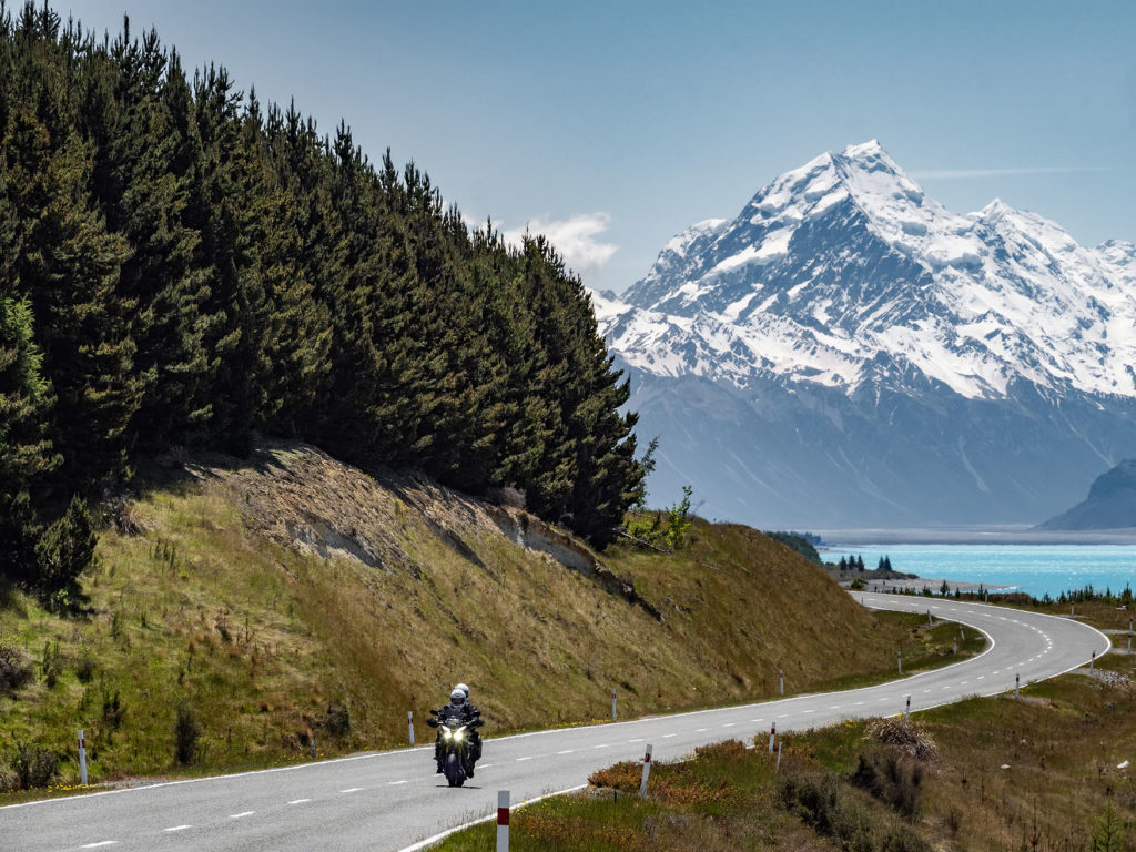
After a nice bit of green laning alongside this small artificial lake (it was formed as a result of the Waitaki hydroelectric project in the late 1970’s) we came back to the main road and headed on to the 30km long Lake Pukaki – the largest of the remaining lakes we would visit and the most memorable. We turned off highway 8 onto the Mount Cook road towards the Sir Edmund Hilary Alpine Centre and Mount Cook. At first the road passed through dense conifer forest which soon thinned out to rolling burnt grass hills with the snowy peaks of Mount Cook in the distance. Coming over a gentle rise we got a first glimpse of the lake as a fluorescent blue strip-light on the horizon. This rapidly grew to one of the most awe-inspiring sights I have seen anywhere. The most intense, seemingly glowing, blue green lake – like someone had plugged it in and turned it on – stretched as far as the eye could see until it merged with the snowy peaks of the majestic Mount Cook in the distance. One of those moments you know no amount of words or images can truly convey. You just have to see it for yourself. Needless to say we spent a lot of time riding up and down this road, never really getting used to the view, before it was time to leave and head over to the equally blue Lake Tekapo and our stop for the night.
 Liz with Lake Pukaki and Mount Cook
 Lake Pukaki and Mount Cook
 Paul & Liz with Lake Pukaki and Mount Cook
 Majestic Mount Cook
Day five: Alpacas and Lupins
Our accommodation at Lake Tekapo was the top floor of a townhouse just up the hill from the lake with a great view over a small field with Alpacas grazing. In the morning I got up very early, silently dressed for riding, and sneaked down to my bike in the garage below. I rolled down the hill and around the corner from the house before starting the engine. I love getting out before places have woken up and I wanted to check out an amazing field of lupins I had seen on the side of the lake. I got the bike as close as I could and trekked over to them. Everything was glistening with dew and backlit with the low morning sun against a backdrop of blue lake and snow capped mountains. Hares were lopping around here and there and stopping to watch me for a while before perceiving no threat and carrying on. It was a wonderful place to be and I indulged myself photographically before returning to the apartment before the others were up.
![]() We can see you !
We can see you !
 Lupin wonderland


After talking to the friendly proprietors of the apartment that morning we decided to take breakfast up at the observatory overlooking the lake. The ride up there and the views were great – the breakfast was not.
Today would be our last day and it was really just a case of riding back to Christchurch to return the bikes. The route was great – rolling hills, fields of sheep, forest sections etc. – but ultimately unremarkable in the face of all that had gone before. The trip was over and we had been so lucky with the weather. In the following weeks our route was plagued with landslides, torrential rain, flooding, high winds and minor earthquakes.
Such is New Zealand – anything can happen!

End of the road